


![]() 33 Ubi Ave 3 #05-57 Singapore 408868
33 Ubi Ave 3 #05-57 Singapore 408868
 Menara MBMR, 1 Jalan Syed Putra , 3-03a, 58000 KL , Malaysia


Trusted platform, secured by
Looking for a Long-Term Rental?
Compare and secure the most competitive rates for 6 months, 1 year, or even 2 years here!

CONTACT US
If your working site is within jurong island or having strict requirement by project owner, you may contact our team at 8831 3875 so we can advise you the right equipment that fit into your site requirement.
If you are looking for long term rental more than 6 months, contact us for better rate.

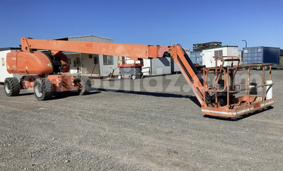
3.0/5
Partner's Rating
Star ratings are provided to reflect the owner’s equipment quality, breakdown respond time, delivery/collection punctuality and communication promptness.

Singapore
Daily
SGD2,500
Weekly
SGD8,000
Monthly
SGD15,000
Two-way Delivery
Delivery price could be varied due to distance and other conditions
: Free
SGD14,250
/M
SGD15,000
Rental Price (Tax Exclusive)
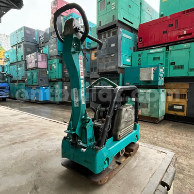
3.0/5
Partner's Rating
Star ratings are provided to reflect the owner’s equipment quality, breakdown respond time, delivery/collection punctuality and communication promptness.
Singapore
Daily
SGD5,000
Weekly
SGD31,500
Monthly
SGD120,000
Two-way Delivery
Delivery price could be varied due to distance and other conditions
SGD 50
SGD114,000
/M
SGD120,000
Rental Price (Tax Exclusive)
Explore More Items!
About Drone Aerial Scanning & Modelling :
Drone aerial scanning and modelling is the process of using drones equipped with high-resolution cameras, LIDAR, or photogrammetry tools to capture detailed data of the Earth’s surface. This data is then transformed into 3D models, topographic maps, digital twins, or orthomosaics for accurate spatial analysis. It's widely used in construction planning, land surveying, mining operations, infrastructure development, and environmental monitoring.
Drone-based scanning and modelling offers a faster, safer, and more cost-efficient alternative to traditional surveying methods. Key benefits include:
From earthworks volume calculations to as-built documentation, drone modelling provides actionable intelligence across various industries.
Choosing the right service provider depends on your project needs, data requirements, and industry standards. Here’s what to consider:
The right drone scanning partner helps you save time, reduce costs, and gain high-quality spatial data for smarter project execution.
![]() 33 Ubi Ave 3 #05-57 Singapore 408868
33 Ubi Ave 3 #05-57 Singapore 408868
Menara MBMR, 1 Jalan Syed Putra , 3-03a, 58000 KL , Malaysia
Trusted platform, secured by